Book 1.—BEFORE THE CONQUEST
Chapter 1.—Chapter I.—The British Period.
Section 3.—Domestic Buildings of the Early Britons
![]()
![]()
![]()
![]()
![]()
![]()
Figures:
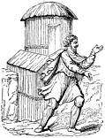
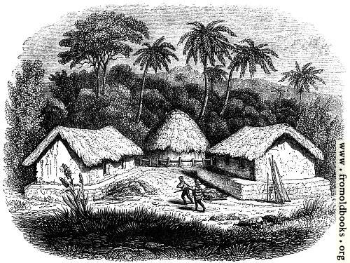
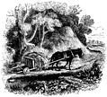
Of the domestic buildings of the early Britons there are no
remains, if we except some circular stone foundations, which may have
been those of houses. It is concluded, perhaps somewhat too hastily,
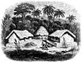
that their houses were little better than the huts of the rude tribes of
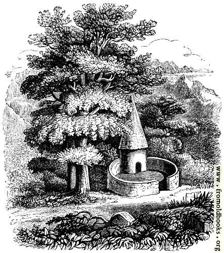
Africa or Asia in our own day (Fig. 49). In the neighbourhood of
Llandaff were, in King’s time, several modern pig-sties, of a peculiar
construction; and he held that the form of these was derived from the
dwellings of the ancient Britons. (Fig. 55.) This form certainly
agrees with the description which Strabo gives of the houses of the
Gauls, which he says were constructed of poles and wattled work, of a
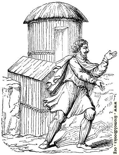
circular form, and with a lofty tapering roof. On the Antonine column
we have representations of the Gauls and the Gaulish houses, but here
the roofs are for the most part with domes (Fig. 50). Strabo further
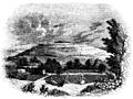
says, “The forests of the Britons are their cities; for, when they
have enclosed a very large circuit with felled trees, they build
within it houses for themselves and hovels for their cattle. These
buildings are very slight, and not designed for long duration.”
Cæsar says, “What the Britons call a town is a tract of woody country,
surrounded by a vallum and a ditch, for the security of themselves and
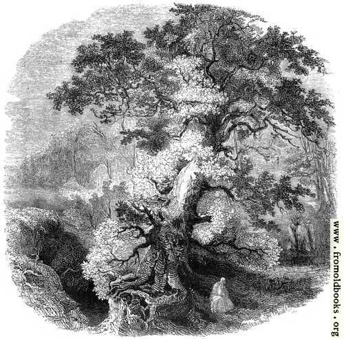
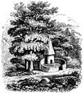
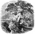
cattle against the incursions of their enemies.” The towns within
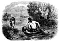
woods were thus fortresses; and here the Druidical worship in the broad
glades, surrounded by mighty oaks which were their natural antiquities,
was cultivated amidst knots of men, held together by common wants as
regarded the present life, and common hopes with reference to the future
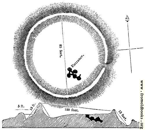
(Fig. 56). A single bank and ditch, agreeing with Cæsar’s description,
is found in several parts of the island. There is such an entrenchment
in the parish of Cellan, Cardiganshire, called Caer Morus. We shall
presently have to speak of the ramparted camps, undoubtedly British,
which are found on commanding hills, exhibiting a skill in the military
art to which Cæsar bore testimony, when he described the capital of
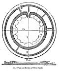
Cassivellaunus as admirably defended both by nature and art. But we here
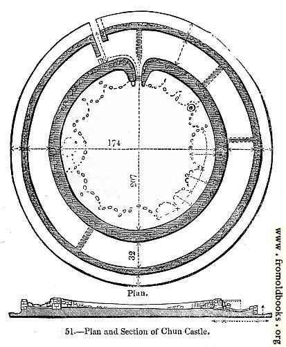
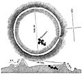
insert a description of Chun Castle, in Cornwall, to furnish a proof that
the skill of the ancient Britons in building displayed itself in more
important works than their wattled huts: “It consists of two circular
walls, having a terrace thirty feet wide between (Fig. 51). The walls
are built of rough masses of granite of various sizes, some five or six
feet long, fitted together, and piled up without cement, but presenting
a regular and tolerably smooth surface on the outside. The outer wall
was surrounded by a ditch nineteen feet in width: part of this wall
in one place is ten feet high, and about five feet thick. Borlase
is of opinion that the inner wall must have been at least fifteen feet
high; it is about twelve feet thick. The only entrance was towards the
south-west, and exhibits in its arrangement a surprising degree of
skill and military knowledge for the time at which it is supposed to
have been constructed. It is six feet wide in the narrowest part, and
sixteen in the widest, where the walls diverge, and are rounded off on
either side. There also appear indications of steps up to the level of
the area within the castle, and the remains of a wall which, crossing the
terrace from the outer wall, divided the entrance at its two parts at its
widest end. The inner wall of the castle incloses an area measuring one
hundred and seventy-five feet north and south, by one hundred and eighty
feet east and west. The centre is without any indication of buildings; but
all around, and next to the wall, are the remains of circular inclosures,
supposed to have formed the habitable parts of the
Figure spread at pages 20 and 21:


Figures:
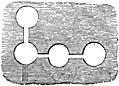
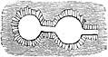
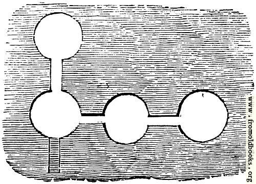
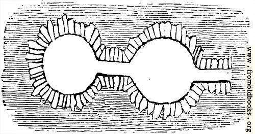
That the Britons were agriculturists, using the term in a larger sense than applies to the cultivation of small patches of land by solitary individuals, we may reasonably infer from some remarkable remains that are not uncommon in these islands. Tacitus, in his account of the manners of the Germans, says, “The Germans were accustomed to dig subterraneous caverns, and then to cover them with much loose mould, forming a refuge from wintry storms, and a receptacle for the fruits of the earth: in this manner the rigour of the frost is softened.” Tacitus also says that these caverns are hiding-places for the people upon the irruption of an enemy. Such pits were common to the ancient people of the East, and are found in modern times in other European countries. There is a singular cavern of this sort at Royston in Hertfordshire, which was discovered in the market-place of that town in 1742. Kent has several such pits. Hasted, the topographer of that county, describes many such in the heaths and fields and woods near Crayford. He says that at the mouth, and thence downward, they are narrow, like the tunnel or passage of a well; but at the bottom they are large and of great compass, so that some of them have several rooms, one within another, strongly vaulted, and supported with pillars of chalk. Camden has given a rude representation of two caverns near Tilbury in Essex, “spacious caverns in a chalky cliff, built very artificially of stone to the height of ten fathoms, and somewhat straight at the top. A person who had been down to view them gave me a description of them.” The chambers in the caverns which Camden depicts, consist either of a large space, with semicircular recesses, or of two chambers, each with three semicircular recesses connected by a passage. The universality of the practice is shown in the caves which were discovered in Ireland, in 1829, which are described in the ‘Transactions of the Antiquarian Society of London,’ vol. xxiii. (Figs. 52, 53, and 54.) There can be little doubt of the use of such caves. Diodorus Siculus expressly says that the Britons laid up their corn in subterranean repositories. There are other remarkable remains whose purposes do not seem quite so clear. These are artificial pits of a conical form. At the top of the Combe Hills, near Croydon in Surrey, is a pit of this sort, minutely described by King. An earlier antiquarian, John Leland,—who peregrinated England and Wales in the time of Henry VIII., and whose descriptions, whenever he enters into detail, are so curious that we sigh over his usual brevity and wish that he were as prolix as the travellers of our own age—thus describes similar pits near Caernarvon: “there be a great number of pits made with hand, large like a bowl at the head, and narrow in the bottom, overgrown in the swart with fine grass, and be scattered here and there about the quarters where the head of Kenner river is, that cometh by Caire Kenner. And some of these will receive a hundred men, some two hundred. They be in the Black Mountain.” (‘Itinerary,’ vol. viii. folio 107, a.)
[see The Works of Tacitus vol. 4 (1737), e.g. at the Online Library of Liberty: “They are likewise wont to scoop Caves deep in the ground, and over them to lay great heaps of dung”
There is also a Project Gutenberg version of the Oxford Translation of The Germany and the Agricola of Tacitus which has wording closer to the quote in Old England, but like most Project Gutenberg texts does not have careful attribution of the exact edition used.
It appears that Charles Knight, editing Old England, changed dung to loose mould.
Note that corn here of course means grain or cereal crop, such as wheat.
Of a later period than that to which we are referring are probably the very singular caves of Hawthornden. Beneath the rock on which Drummond and Jonson sate [sic], looking out upon the delicious glen whose exquisite beauties would seem the natural abodes of peacefulness and innocence, are the hiding-places of remote generations. Long galleries and dreary caverns, cut in the rock, are peopled by tradition with the brave and the oppressed hiding from their enemies. Here we are shown the king’s bedchamber; and another cave, whose walls are cut into small recesses of about a foot square, was the king’s drawing-room. He was here surrounded by ample conveniences for arranging the petty treasures of his solitude. Setting these traditions aside, we may reasonably conclude that the caves of Hawthornden were at once hiding-places and storehouses: and it is not carrying our fancies too far to believe that the shelved cavities of the rock were receptacles for food, in small portions—the oatmeal and the pulse that were thus preserved from worms and mildew.
Figures:
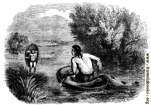
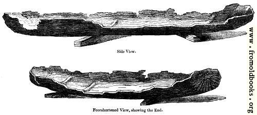
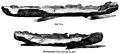
The primitive inhabitants of all sea-girt countries are fishermen. It is impossible not to believe that the people of Britain, having at their command the treasures of wide æstuaries and deep rivers, were fishermen to a large extent. The Britons must always have been a people who were familiar with the waters. The Severn and the Wye have still their coracles—little boats so peculiar in their construction that we may readily conceive them to belong to a remote antiquity. Gibson, the translator and best editor of Camden, has described these boats upon the Severn: “The fishermen in these parts use a small thing called a coracle, in which one man being seated will row himself with incredible swiftness with one hand, whilst with the other he manages his net, angle, or other fishing tackle. It is of a form almost oval, made of split sally-twigs interwoven (willow-twigs), round at the bottom, and on that part which is next [to] the water it is covered with a horse-hide. It is about five feet in length and three in breadth, and is so light that, coming off the water, they take them upon their backs and carry them home.” Such, we may conclude, were the fishing-boats of our primitive ancestors. (Fig. 58.) Some of the Roman writers might lead us to believe that the Britons had boats capable of distant navigation; but this is doubted by most careful inquirers. But the light boats which were peculiar to the island were certainly of a construction well suited to their objects; for Cæsar, in his History of the Civil War, tells us that he had learnt their use in Britain, and availed himself of boats of a similar formation in crossing rivers in Spain. These were probably canoes, hollowed out of a single tree. Such have been found, from seven to eight feet long, in morasses and in the beds of rivers, at very distant parts of the country—in Dumfries, and in the marshes of the Medway. In 1834 a boat of this description was discovered in a creek of the river Arun, in the village of North Stoke, Sussex (Fig. 57). In draining the Martine Mere, or Marton Lake, in Lancashire, eight canoes, each formed of a single tree, were found sunk deep in the mud and sand. The pearl-fishery of Britain must have existed before the Roman invasion, for Suetonius says that the hope of acquiring pearls was a main inducement to Cæsar to attempt the conquest of the country. The great conqueror himself, according to Pliny, the naturalist, dedicated to Venus a breastplate studded with British pearls, and suspended it in her temple at Rome. In a later age the pearls of Caledonia were poetically termed by Ausonius the white shell-berries. Camden thus describes the pearls of the little river Irt in Cumberland: “In this brook the shell-fish, eagerly sucking in the dew, conceive and bring forth pearls, or, to use the poet’s words, shell-berries. These the inhabitants gather up at low-water; and the jewellers buy them of the poor people for a trifle, but sell them at a good price. Of these, and such like, Marbodæus seems to speak in that verse,
Ausonius’ Mosella:
The milky berries that grow in oysters
Decimus Magnus Ausonius, 4th Century AD
‘Gignit et insignes antiqua Britannia baccas.’
(‘And Britain’s ancient shores great pearls produce.’)’
Figures:
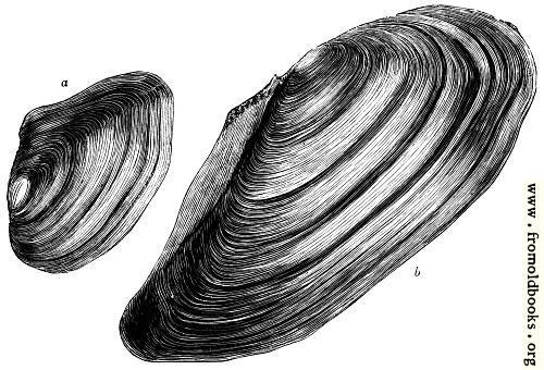
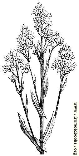
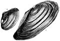
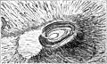
The British pearls were not found in the shells of the oyster, as is often thought, but in those of a peculiar species of mussel (Fig. 59). The oysters of Britain, celebrated by Pliny and Juvenal after the Roman conquest, contributed, we may reasonably suppose, to the food of the primitive inhabitants.
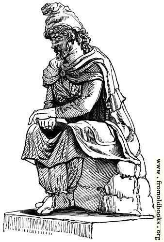
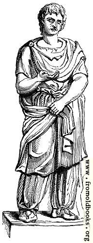
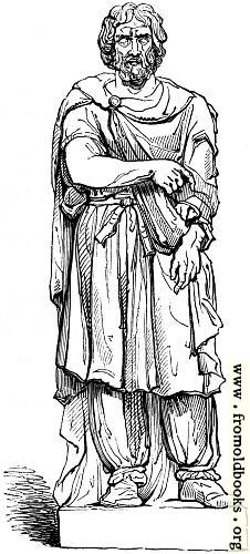
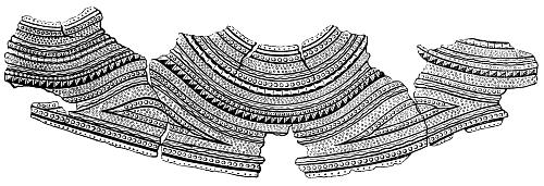
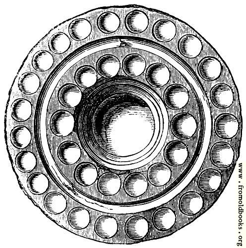
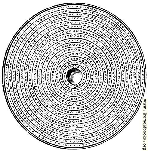
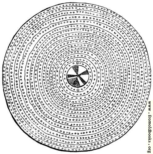
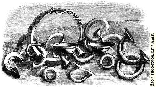
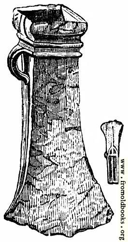
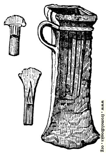
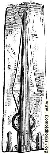
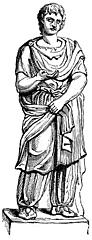
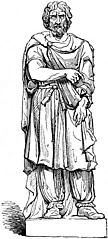
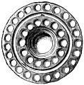
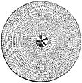
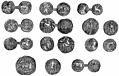
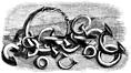
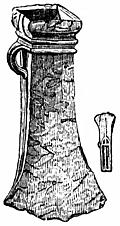
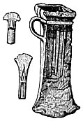
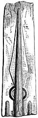
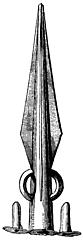
The dresses of the inhabitants of Britain before the Roman invasion are not, like those of the people of ancient Egypt, and other countries advanced in the practice of the imitative arts, to be traced in painting or sculpture. In Roman statues we have the figures of ancient Gauls, which give us the characteristic dress of the Celtic nations: the braccæ, or close trowsers, the tunic, and the sagum, or short cloak (Figs. 61, 62, 63). The dye of the woad was probably used for this cloth, as it was to colour the skins of the warriors stripped for battle (Fig. 60). It is difficult to assign an exact period to their use of cloth in preference to skins. It is equally difficult to determine the date of those valuable relics which have been found in various places, exhibiting a taste for symmetry and nice workmanship in the fabrication of their weapons, offensive and defensive, and the ruder decorations of their persons. Such are the remains of a golden breast-plate found at Mold in Flintshire, now in the British Museum (Fig. 64). Such are the shields (Figs. 65, 66, 67), of one of which (Fig. 67) Sir Samuel Meyrick, its possessor, says, “It is impossible to contemplate the artistic portions without feeling convinced that there is a mixture of British ornaments with such resemblances to the elegant designs on Roman works as would be produced by a people in a state of less civilization.” Torques, or gold and bronze necklaces composed of flexible bars, were peculiar to the people of this country. Of all these matters we shall have further to speak in the next chapter—the Roman period. There also we may more properly notice the great variety of British coins, of which we here present a group (Fig. 68). Ring-money, peculiar to the Celtic nations, undoubtedly existed in Ireland previous to the domination of the Romans in Britain. Although Cæsar says that the ancient Britons had no coined money, there is sufficient probability that they had their metal plates for purposes of currency, such being occasionally found in English barrows. The Ring-money (Fig. 69) has been found in great quantities in Ireland, of bronze, of silver, and of gold. The rings vary in weight; but they are all exact multiples of a standard unit, showing that a uniform principle regulated their size, and that this was determined by their use as current coin. The weapons of the ancient Britons show their acquaintance with the casting of metals. Their axe-heads, called Celts, are composed of ten parts of copper and one of tin (Figs. 70 and 71); their spear-heads, of six parts of copper and one of tin. Moulds for spear-heads have been frequently found in Britain and Ireland (Figs. 72 and 73).
Figures:
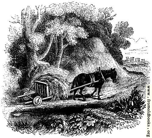
There are no remains of those terrible war-chariots of the Britons which Cæsar describes as striking terror into his legions. King, who labours very hard to prove that the people who stood up not only with undaunted courage, but military skill, against the conquerors of the world, were but painted savages, considers that the British war-chariot was essentially the same as the little low cart which the Welsh used in his day for agricultural purposes (Fig. 74). The painters have endeavoured to realize the accounts of the Roman writers, with more of poetry, and, we believe, with more of truth (Fig. 75).
Figures:
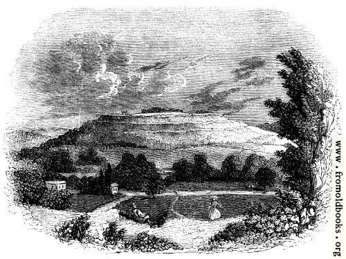
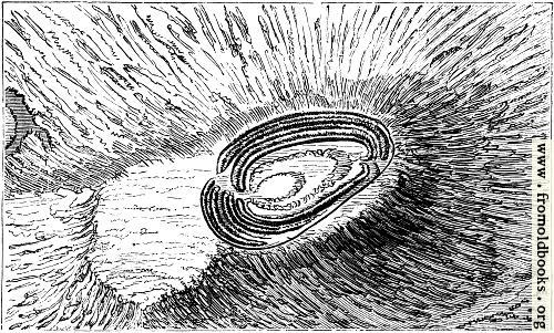
But if the chariots have perished,—if the spears and the axe-heads are doubtful memorials of the warlike genius of the people,—not so are the mighty earth-works which still attest that they defended themselves against their enemies upon a system which bespeaks their skill as well as their valour. The ramparted hill of Old Sarum, with terrace upon terrace rising upon its banks and ditches, and commanding the country for miles around, is held not merely to have been a Roman station, or a British station after the Romans, but a fortified place of the people of the country, even in the time of the great Druidical monuments which are found scattered over the great plain where this proud hill still stands in its ancient majesty. The Roman walls, the Saxon towers, the Norman cathedral, which have successively crowned this hill, have perished, but here it remains, with all the peculiar character of a British fortress still impressed upon it (Fig. 23). Such a fortress is the Herefordshire beacon (Fig. 76) which forms the summit of one of the highest of the Malvern hills, and looks down upon that glorious valley of the Severn which, perhaps more than any other landscape, proclaims the surpassing fertility of ‘Old England.’ Such is, in all likelihood, the castellated hill near Wooler, in Northumberland, which rises two thousand feet above the adjacent plain, with its stone walls, and ditches, and crumbling cairns. It was in these hill-forts that the Britons so long defied the Roman power; and one of them (near the confluence of the Coln and Teme, in Shropshire) is still signalised by the name of one of the bravest of those who fought for the independence of their country—Caer-Caradoc, the castle of Caractacus (Fig. 77). The Catter-thuns of Angus (Forfarshire) are amongst the most remarkable of the Caledonian strong-holds. They are thus described by Pennant, in his ‘Tour in Scotland:’—“After riding two miles on black and heathy hills, we ascended one divided into two summits; the higher named the White, the lower the Black Catter-thun, from their different colour. Both are Caledonian posts; and the first of most uncommon strength. It is of an oval form, made of a stupendous dike of loose white stones, whose convexity, from the base within to that without, is a hundred and twenty-two feet. On the outside, a hollow, made by the disposition of the stones, surrounds the whole. Round the base is a deep ditch, and below that, about a hundred yards, are vestiges of another, that went round the hill. The area within the stony mound is flat; the greater axis or length of the oval is four hundred and thirty-six feet; the transverse diameter, two hundred. Near the east side is the foundation of a rectangular building; and on most parts are the foundations of others small and circular; all which had once their superstructures, the shelter of the possessors of the post. There is also a hollow, now almost filled with stones, the well of the place. The literal translation of the word Catter-thun is Camp-town.” The Vitrified forts of Scotland are so mysterious in their origin and their uses, some holding them to be natural volcanic productions, others artificial buildings of earth, made solid by the application of fire, without cement, that we may safely omit them in this notice of the British period.
These forts may date from as early as 1000 BC; the stone has been melted into glass, although the process by which this was done remains unknown. It is not sufficient to suggest an accidental fire of wooden structures, as temperatures of over a thousand degrees are said to be needed. The largest vitrified fort is half a mile in length. The forts occur in England as well as Scotland; those in Scotland at least are mildly radioactive.
See for example Isle of Avalon as a starting point.
In speaking of those ancient works in these islands which were constructed upon a large scale for the defence of the country and for the accommodation of the people, it is difficult to define the precise share of the ancient Britons in their construction, as compared with the labours of successive occupants of the country. Old Sarum, for example, has the characteristics of a work essentially different from the camps and castles of Roman origin. But the Romans, too wise a people to be destroyers, would naturally improve the old defences of the island, and adapt them to their own notions of military science. So, we imagine, it would have been with what we are accustomed to call the four great Roman Ways. The old chroniclers record that King Dunwallo (called also Moliuncius or Mulmutius) “began the four highways of Britain, the which were finished and perfited of Belinus his son.” This is the Mulmutius whose civilizing deeds are thus described by Spenser:—
“Then made he sacred laws, which some men say
Were unto him reveal’d in vision;
By which he freed the traveller’s highway,
The Church’s part, and ploughman’s portion,
Restraining stealth and strong extortion;
The gracious Numa of Great Britainy:
For, till his days, the chief dominion
By strength was wielded without policy:
Therefore he first wore crown of gold for dignity.”
Camden, who naturally enough has a disposition, from the nature of his learning, to hold that the civilization of Britain began from the Roman conquest, laughs to scorn the notion of the great highways being made before the Romans:—“Some imagine that these ways were made by one Mulmutius, God knows who, many ages before the birth of Christ; but this is so far from finding credit with me, that I positively affirm, they were made from time to time by the Romans. When Agricola was Lieutenant here, Tacitus tells us, that ‘the people were commanded to carry their corn about, and into the most distant countries; not to the nearest camps, but to those that were far off and out of the way.’ And the Britons (as the same author has it) complained, ‘that the Romans put their hands and bodies to the drudgery of clearing woods and paving fens, with stripes and indignities to boot.’ And we find in old records, ‘In the days of Honorius and Arcadius, there were made in Britain certain highways from sea to sea.’ That they were the work of the Romans, Bede himself tells us: ‘The Romans lived within that wall (which, as I have already observed, Severus drew across the island) to the southward; as the cities, temples, bridges, and highways made there, do plainly testify at this day.’ ” But in these quotations there is nothing to prove that there were not roads in Britain before the Romans. That the more ancient roads were not the magnificent works which the Romans afterwards constructed we may well believe; but, on the other hand, it is impossible to imagine that a people accustomed to military movements were without roads. The local circumstances also belonging to the great Druidical monuments, such as Stonehenge and Abury, indicate with sufficient clearness that they were not solely constructed with reference to the habits of a stationary population, but that they were centres to which great bodies of the people resorted at particular seasons of solemnity. We may take, therefore, the statements of the old chroniclers with regard to the more ancient and important of the highways as not wholly fabulous. Robert of Gloucester, in his rude rhyme, has told us as much as is necessary here to say about them:
“Faire weyes many on ther ben in Englonde;
But four most of all ther ben I uuderstonde,
That thurgh an old kynge were made ere this,
As men schal in this boke aftir here tell I wis.
Fram the South into the North takith Erminge-strete.
Fram the East into the West goeth Ikeneld-strete.
Fram South-est to North-west, that is sum del grete
Fram Dover into Chestre goth Watlyng-strete.
The ferth of thise is most of alle that tilleth fram Tateneys.
Fram the South-west to North-est into Englondes ende
Fosse men callith thilke wey that by mony town doth wende.
Thise foure weyes on this londe kyng Belin the wise
Made and ordeined hem with gret fraunchise.”
We have thus hastily presented a sketch, imperfect in the details, but not without its impressiveness if regarded as exhibiting the solemn picture of man struggling to comprehend the Infinite through clouds and darkness—we have thus attempted to group the memorials of ages which preceded the Roman domination in ‘Old England.’ We look back upon these earliest records of a past state of society with wonder not unmixed with awe, with shuddering but not with hatred:
“Yet shall it claim our reverence, that to God,
Ancient of days! that to the eternal Sire
These jealous ministers of law aspire,
As to the one sole fount whence Wisdom flow’d,
Justice, and Order. Tremblingly escaped,
As if with prescience of the coming storm,
That intimation when the stars were shaped;
And still, ’mid yon thick woods, the primal truth
Glimmers through many a superstitious form
That fills the soul with unavailing ruth.”