Book 1.—BEFORE THE CONQUEST
Chapter 2.—Chapter II.—The Roman Period.
Section 2.—Richborough to Reculver
![]()
![]()
![]()
![]()
![]()
![]()
Figures:
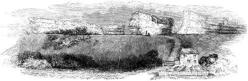
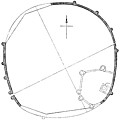
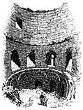
It was a little before the commencement of a glorious corn harvest that we first saw Richborough. Descending from the high fertile land of the Isle of Thanet, we passed Ebbefleet, the spot in Pegwell Bay where tradition says Hengist and Horsa landed, to carry war and rapine into the country. The coast here wears an aspect of melancholy dreariness. To the east we looked back upon the bold cliff of Ramsgate; to the west, upon the noble promontory of the South Foreland. But all the land space between these two extremities of the bay is a vast flat, drained in every direction by broad ditches, amidst which, in propitious seasons, thousands of sheep find a luxuriant though coarse pasture. At low-water the sea retires many furlongs from this flat shore; and then, the fisherboy fills his basket with curious shells, which are here found in great variety. When the tide has ebbed, a narrow stream may be traced for a long distance through the sand, which, when the salt wave has receded, still fills the little channel into which it empties itself from its inland source. This is the river Stour, whose main branch, flowing from Ashford by the old Roman Castle of Chilham, and onward to Canterbury, forms the boundary of the Isle of Thanet on the south-west; and making a sudden bend southerly to Sandwich, returns again in a northerly direction to empty itself into its sea-channel in Pegwell Bay. The road crosses the peninsula which is formed by this doubling of the river. At about a mile to the west is a gentle hill crowned with a large mass of low wall. At the distance of two or three miles we distinctly see that this is some remarkable object. It is not a lofty castle of the middle ages, such as we sometimes look upon, with tower and bastion crumbling into picturesque ruin; but here, on the north side, is a long line of wall, without a single aperture, devoid alike of loophole or battlement, and seemingly standing there only to support the broad masses of ivy which spread over its surface in singular luxuriance. We take boat at a little ferry-house, at a place called Saltpans. Leland, when he went to Richborough three hundred years ago, found a hermit there; and he says, “I had antiquities of the heremite, the which is an industrious man.” So say we of the ferry-man. He has small copper coins in abundance, which tell what people have been hereabout. He rows us down the little river for about three-quarters of a mile, and we are under the walls of Richborough Castle (Fig. 99). This is indeed a mighty monument of ages that are gone. Let us examine it with somewhat more than common attention.
Figures:
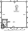
Ascending the narrow road which
passes the cottage built at the foot of the bank, we reach some masses
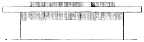
of wall which lie below the regular line (Plan 98). Have these fallen
from their original position, or do they form an outwork connected
with fragments which also appear on the lower level of the slope?
This is a question not very easy to decide from the appearance of the
walls themselves. Another question arises, upon which antiquarian writers
have greatly differed. Was there a fourth wall on the south-eastern side
facing the river? It is believed by some that there was such a wall,
and that the castle or camp once formed a regular parallelogram. It is
difficult to reconcile this belief with the fact that the sea has been
constantly retiring from Richborough, and that the little river was
undoubtedly once a noble estuary.
Bede, who wrote his ’Ecclesiastical History’
in the beginning of the eighth century, thus describes the
branch of the river which forms the Isle of Thanet, and which now runs a
petty brook from Richborough to Reculver: “On the east side of Kent is
the Isle of Thanet, considerably large, that is, containing, according
to the English way of reckoning, six hundred families, divided from the
other land by the river Wantsumu, which is about three furlongs over,
and fordable only in two places, for both ends of it run into the sea.”
Passing by the fragments of which we have spoken, we are under the north
(strictly north-east) wall,—a wondrous work, calculated to impress
us with a conviction that the people who built it were not the petty
labourers of an hour, who were contented with temporary defences and
frail resting-places. The outer works upon the southern cliff of Dover,
which were run up during the war with Napoleon at a prodigious expense,
are crumbling and perishing, through the weakness of job and contract,
which could not endure for half a century. And here stand the walls of
Richborough, as they have stood for eighteen hundred years, from twenty
to thirty feet high, in some places with foundations five feet below
the earth, eleven or twelve feet thick at the base, with their outer
masonry in many parts as perfect as at the hour when their courses of
tiles and stones were first laid in beautiful regularity. The northern
wall is five hundred and sixty feet in length. From the eastern end,
for more than two-fifths of its whole length, it presents a surface
almost wholly unbroken. It exhibits seven courses of stone, each course
about four feet thick, and the courses separated each from the other
by a double line of red or yellow tiles, each tile being about an inch
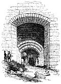
and a half in thickness. The entrance to the camp through this north
wall is very perfect, of the construction marked in the plan. This
was called by the Romans the Porta Principalis, but in after times the
Postern-gate. We pass through this entrance, and we are at once in the
interior of the Roman Castle. The area within the walls is a field of five
acres, covered, when we saw it, with luxuriant beans, whose green pods
were scarcely yet shrivelled by the summer sun. Towards the centre of
the field, a little to the east of the postern-gate, was a large space
where the beans grew not. The area within the walls is much higher in
most places than the ground without; and therefore the walls present a far
more imposing appearance on their outer side.
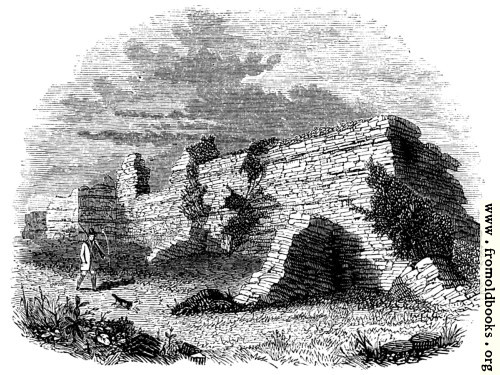
As we pass along the north wall to its western extremity,
King, Edward, 1799-1805, Munimenta Antiqua
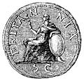
Of the early importance of Richborough we have the most decisive evidence. Bede, eleven hundred years ago, speaks of it as the chief tiling of note on the southern coast. Writing of Britain, he says, “On the south it has the Belgic Gaul; passing along whose nearest shore there appears the city called Rutubi Portus, the which port is now by the English nation corruptly called Reptacester: the passage of the sea from Gesoriacum, the nearest shore of the nation of the Morini, being fifty miles, or, as some write, four hundred and fifty furlongs.” Camden thus describes the changes in the name of this celebrated place: “On the south side of the mouth of Wantsum (which they imagine has changed its channel), and over against the island, was a city, called by Ptolemy Rhutupiæ; by Tacitus, Portus Trutulensis, for Rhutupensis, if B. Rhenanus’s conjecture hold good; by Antoninus, Rhitupis Portus; by Ammianus, Rhutupiæ statio; by Orosius, the port and city of Rhutubus; by the Saxons (according to Bede), Reptacester, and by others Ruptimuth; by Alfred of Beverley, Richberge; and at this day Richborrow: thus has time sported in varying one and the same name.” It is unnecessary for us here to enter into the question whether Rhutupiæ was Richborough, or Sandwich, or Stonar. The earlier antiquaries, Leland, Lambarde, Camden, decide, as they well might, that the great Roman Castle of Richborough was the key of that haven which Juvenal has celebrated for its oysters (Sat. iv.) and Lucan for its stormy seas (lib. vi.). Our readers, we think, will prefer, to such a dissertation, that most curious description of the place which we find in Leland’s ‘Itinerary’—a description that has been strangely neglected by most modern topographers: “Ratesburgh, otherwise Richeboro, was, or ever the river of Sture did turn his bottom or old canal within the Isle of Thanet; and by likelihood the main sea came to the very foot of the castle. The main sea is now off of it a mile, by reason of woze (ooze) that hath there swollen up. The site of the old town or castle is wonderful fair upon a hill. The walls, the which remain there yet, be in compass almost as much as the Tower of London. They have been very high, thick, strong, and well embattled. The matter of them is flint, marvellous and long bricks, white and red after the Britons’ fashion. The cement was made of sea-sand and small pebble. There is a great likelihood that the goodly hill about the castle, and especially to Sandwich-ward, hath been well inhabited. Corn groweth on the hill in marvellous plenty; and in going to plough there hath, out of mind, found, and now is, more antiquities of Roman money than in any place else of England. Surely reason speaketh that this should be Rutupinum. For beside that the name somewhat toucheth, the very near passage from Clyves, or Cales, was to Ratesburgh, and now is to Sandwich, the which is about a mile off; though now Sandwich be not celebrated because of Goodwin Sands and the decay of the haven. There is, a good flight shot off from Ratesburgh, towards Sandwich, a great dike, cast in a round compass, as it had been for fence of men of war. The compass of the ground within is not much above an acre, and it is very hollow by casting up the earth. They call the place there Lytleborough. Within the castle is a little parish church of St. Augustine, and an Hermitage. I had antiquities of the hermit, the which is an industrious man. Not far from the Hermitage is a cave where men have sought and digged for treasure. I saw it by candle within, and there were conies (rabbits). It was so straight, that I had no mind to creep far in. In the north side of the Castle is a head in the wall, now sore defaced with weather. They call it Queen Bertha Head. Near to that place, hard by the wall, was a pot of Roman money found.”
Figures:
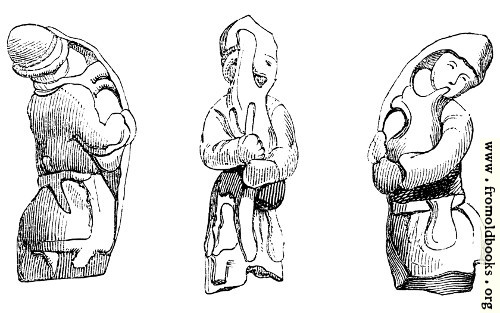
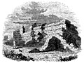
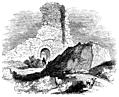
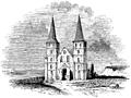
In the bean-field within the walls of Richborough there was a space where no beans grew, which we could not approach without trampling down the thick crop. We knew what was the cause of that patch of unfertility. We had learnt from the work of Mr. King, who had derived his information from Mr. Boys, the local historian of Sandwich, that there was, “at the depth of a few feet, between the soil and rubbish, a solid regular platform, one hundred and forty-four feet in length, and a hundred and four feet in breadth, being a most compact mass of masonry composed of flint stones and strong coarse mortar.” This great platform, “as hard and entire in every part as a solid rock,” is pronounced by King to have been “the great parade, or Augurale, belonging to the Prætorium, where was the Sacellum for the eagles and ensigns, and where the sacrifices were offered.” But upon this platform is placed a second compact mass of masonry, rising nearly five feet above the lower mass, in the form of a cross, very narrow in the longer part which extends from the south to the north (or, to speak more correctly, from the south-west to the north-east), but in the shorter transverse of the cross, which is forty-six feet in length, having a breadth of twenty-two feet. This cross, according to King, was the site of the Sacellum. Half a century ago was this platform dug about and under, and brass and lead, and broken vessels were found, and a curious little bronze figure of a Roman soldier playing upon the bagpipes (Fig. 102). Again has antiquarian curiosity been set to work, and labourers are now digging and delving on the edge of the platform, and breaking their tools against the iron concrete. The workmen have found a passage along the south and north sides of the platform, and have penetrated, under the platform, to walls upon which it is supposed to rest, whose foundations are laid twenty-eight feet lower. Some fragments of pottery have been found in this last excavation, and the explorers expect to break through the walls upon which the platform Tests, and find a chamber. It may be so. Looking at the greater height of the ground within the walls, compared with the height without, we are inclined to believe that this platform, which is five feet in depth, was the open basement of some public building in the Roman time. To what purpose it was applied in the Christian period, whether of Rome or Britain, we think there can be no doubt. The traveller who looked upon it three centuries ago tells us distinctly, “within the Castle is a little parish church of St. Augustine, and an hermitage.” When Camden saw the place, nearly a century after Leland, the little parish church was gone. He found no hermitage there, and no hermit to show him antiquities. He says, “To teach us that cities die as well as men, it is at this day a corn-field, wherein when the corn is grown up one may observe the draughts of streets crossing one another, for where they have gone the corn is thinner.... Nothing now remains but some ruinous walls of a square tower cemented with a sort of sand extremely binding.” He also says that the crossings of the streets are commonly called St. Augustine’s Cross. There is certainly some confusion in this description of crossings as one cross. To us it appears more than probable that the “little parish church of St. Augustine,” which Leland saw, had this cross for its foundation, and that when this church was swept away—when the hermit who dwelt there, and there pursued his solitary worship, fell upon evil times—the cross, with a few crumbling walls, proclaimed where the little parish church had stood, and that this was then called St. Augustine’s Cross (Fig. 101). The cross is decidedly of a later age than the platform: the masonry is far less regular and compact. Camden, continuing the history of Richborough after the Romans, says, “This Rutupiæ flourished likewise after the coming in of the Saxons, for authors tell us it was the palace of Ethelbert, king of Kent, and Bede honours it with the name of a city.” The belief that the palace of Ethelbert was upon this commanding elevation, so strengthened by art, full no doubt of remains of Roman magnificence, the key of the broad river which allowed an ample passage for ships of burthen from the Channel to the estuary of the Thames, is a rational belief. But Lambarde says of Richborough, “Whether it were that palace of King Ethelbert from whence he went to entertain Augustine, he that shall advisedly read the twenty-fifth chapter of Beda his first book shall have just cause to doubt; forasmuch as he showeth manifestly that the king came from his palace into the Isle of Thanet to Augustine, and Leland saith that Richborough was then within Thanet, although that since that time the water has changed its old course and shut it clean out of the island.” This is a refinement in the old Kentish topographer which will scarcely outweigh the general fitness of Richborough for the palace of the Saxon king. The twenty-fifth chapter of Bede is indeed worth reading “advisedly;” but not to settle this minute point of local antiquarianism. We have given Bede’s description of the Isle of Thanet, in which island, he says, “landed the servant of our Lord, Augustine, and his companions, being as it is reported near forty men.” The king, according to Bede’s narrative, hearing of their arrival, and the nature of their mission, ordered them to stay in the island, where they should be furnished with all necessaries. “Some days after, the king came into the island, and, sitting in the open air, ordered Augustine and his companions to be brought into his presence. For he had taken precaution that they should not come to him in any house, according to the ancient superstition, lest, if they had any magical arts, they might at their coming impose upon and get the better of him. But they came furnished with divine virtue, not with diabolical, bearing a silver cross for their banner, and the image of our Lord and Saviour painted on a board, and, singing the Litany, offered up their prayers to the Lord for their own, and the eternal salvation of those to whom they were come. Having, pursuant to the king’s commands, after sitting down, preached to him and all his attendants there present the Word of Life; he answered thus: ’Your words and promises are very taking, but in regard that they are new and uncertain, I cannot approve of them, forsaking that which I have so long followed with the whole English nation. But because you are come from far into my kingdom, and, as I conceive, are desirous to impart to us those tilings which you believe to be true, and most beneficial, we will not molest you, but rather give you favourable entertainment, and take care to supply you with your necessary sustenance; nor do we forbid you by preaching to gain as many as you can to your religion.’ Accordingly he gave them a dwelling-place in the city of Canterbury, which was the metropolis of all his dominions, and pursuant to his promise, besides allowing them their diet, permitted them to preach.” This memorable transaction, told with such touching simplicity a little more than a century after its occurrence, by the illustrious monk of Jarrow, imparts a far deeper interest to this locality than its Roman memorials.
Figure spread at pages 32 and 33:


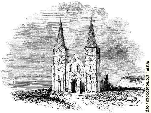
Figures:
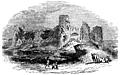
John Twyne, a celebrated antiquarian who lived in the sixteenth century, says, “There be right credible persons yet living that have often seen not only small boats but vessels of good burden to pass to and fro upon the Wantsum, where now the water, especially towards the west, is clean excluded; and there be apparent marks that Sarr, where they now go over, was a proper haven.” Those who have traversed the low country which lies between Reculver and Sandwich—a task not very easily to be accomplished unless the pedestrian can leap the broad ditches which drain the marsh—will readily comprehend how, in the course of eighteen centuries, the great estuary may have dwindled into a petty rill. There is nothing in the nature of the country to prevent one believing that a large arm of the sea cut off the Isle of Thanet from the mainland of Kent, and that this channel, in the time of the Romans, formed the readiest passage from the coast of Gaul to London. The late Mr. John Rickman has well described the course of communication between the Continent and Britain:—“The Roman roads in Kent deserve notice as having been planned with an intention of greater scope than (within my knowledge) has been ascribed to them. The nearest and middle harbour of access from Gaul was evidently Dover; but whenever the wind was unfavourable for a direct passage, further resource became desirable, and from Lemanis (Lymne, near Hythe) and Ritupæ (Richborough, near Sandwich) branch roads were made, joining the Dover road at Canterbury; so that a dispatch-boat, by sailing from the windward port, or steering for the leeward of these three ports, could seldom fail of a ready passage to or from the Continent; and especially it is remarkable that the prevailing south-west wind (with this advantage) permitted a direct passage from Gessoriacum or Itius (Boulogne or Witsand) to Ritupæ, in effect to London; the Wantsum channel then and long after existing within the Isle of Thanet to Regulbium (Reculver) on the Thames, being that by which early navigation was sheltered in its access to the British metropolis. Indeed the first paragraph of the Itinerary of Antoninus gives the reputed distance from Gessoriacum to Ritupæ, as if more important or more in use than the shorter passage to Dover.” (’Archæologia,’ vol. xxviii.) With this explanation we can comprehend the advantage of the Roman position at Reculver. Through this broad channel of the Wantsum the Roman vessels from Boulogne sailed direct into the Thames, without going round the North Foreland; and the entrance to the estuary was defended by the great Castle of Richborough at the one end, and by the lesser Castle of Reculver at the other. The Roman remains still existing at Reculver are less interesting than those at Richborough, chiefly because they are of less magnitude and are more dilapidated. Very close to the ruins of the ancient church, whose spires were once held in such reverence that ships entering the Thames were wont to lower their top-sails as they passed (Fig. 103), is an area, now partly under the plough and partly a kitchen garden. It is somewhat elevated above the surrounding fields; and, descending a little distance to the west of the ruined church, we are under the Roman wall, which still stands up on the western and southern sides with its layers of flat stone and concrete, defying the dripping rain and the insidious ivy. The castle stood upon a natural rising ground, beneath which still flows the thread-like stream of the river Stour or Wantsum. Although it was once the key of the northern mouth of the great estuary, it did not overhang the sea on the northern cliff, as the old church ruin now hangs. When the legions were here encamped, it stood far away from the dashing of the northern tide, which for many generations has been here invading the land with an irresistible power. Century after century has the wave been gnawing at this cliff; and, as successive portions have fallen, the bare sides have presented human bones, and coins, and fragments of pottery, and tessellated pavements, which told that man had been here, with his comforts and luxuries around him, long before Ethelbert was laid beneath the floor of the Saxon church, upon whose ruins the sister spires of the Norman rose, themselves to be a ruin, now preserved only as a sea-mark. Reculver is a memorable example of the changes produced in the short period of three centuries. Leland’s description of the place is scarcely credible to those who have stood beneath these spires, on the very margin of the sea, and have looked over the low ruined wall of the once splendid choir, upon the fishing-boats rocking in the tide beneath:—“Reculver is now scarce half a mile from the shore.” In another place—“Reculver standeth within a quarter of a mile or a little more from the sea-side. The town at this time is but village-like; sometime where as the parish church is now was a fair and a great abbey, and Brightwald, Archbishop of Canterbury, was of that house. The old building of the church of the Abbey remaineth, having two goodly spiring steeples. In the entering of the choir is one of the fairest and the most ancient cross that ever I saw, nine feet, as I guess, in height: it standeth like a fair column.” Long ago has the cross perished, with its curiously wrought carvings and its painted images; and so has perished the “very ancient book of the Evangeles,” which Leland also describes. The Romans have left more durable traces of their existence at Reculver than the ministers of religion, who here, for centuries, had sung the daily praises of Him who delivereth out of their distress those “that go down to the sea in ships, and occupy their business in great waters.” The change in names of places sometimes tells the story of their material changes. The Regulbium of the Romans became the Raculfcester of the Saxons, cester indicating a camp; that name changes when the camp has perished, and the great abbey is flourishing, to Raculfminster; the camp and the abbey have both perished, and we have come back to the Latin Regulbium, in its Anglicised form of Reculver. Some fiercer destruction even than that which swept away the abbey probably fell upon the Roman city. Gibson, speaking of the coins and jewellery which have been found at various times at Reculver, says, “These they find here in such great quantities that we must needs conclude it to have been a place heretofore of great extent, and very populous, and that it has one time or other underwent some great devastation, either by war or fire, or both. I think I may be confident of the latter, there being many patterns found of metals run together.” The antiquities of Regulbium are fully described in the elegant Latin treatise of Dr. Battely, ’Antiquitates Rutupinæ,’ 1711.